http://www.loc.gov/exhibits/lewisandclark/lewis-landc.html#56
Lewis and Clark Pt II
Jefferson's Secret Message to Congress
While Jefferson made no effort to hide the Lewis and Clark expedition from Spanish, French, and British officials, he did try to shield it from his political enemies. By the time he was ready to request funds for the enterprise, Jefferson's relationship with the opposition in Congress was anything but friendly. When the president suggested including expedition funding in his regular address to Congress, Secretary of the Treasury Albert Gallatin (1761-1849) urged that the request be made in secret. The message purported to focus on the state of Indian trade and mentioned the proposed western expedition near the end of the document.
Jefferson's Instructions for Meriwether Lewis
No document proved more important for the exploration of the American West than the letter of instructions Jefferson prepared for Lewis. Jefferson's letter became the charter for federal exploration for the remainder of the nineteenth century. The letter combined national aspirations for territorial expansion with scientific discovery. Here Jefferson sketched out a comprehensive and flexible plan for western exploration. That plan created a military exploring party with one key mission--finding the water passage across the continent "for the purposes of commerce"--and many additional objectives, ranging from botany to ethnography. Each section of the document was really a question in search of a western answer. Two generations of American explorers marched the West in search of those answers.
Jefferson Peace Medal
The American republic began to issue peace medals during the first Washington administration, continuing a tradition established by the European nations. Lewis and Clark brought at least eighty-nine medals in five sizes in order to designate five "ranks" of chief. In the eyes of Americans, Indians who accepted such medals were also acknowledging American sovereignty as "children" of a new "great father." And in a moment of imperial bravado, Lewis hung a peace medal around the neck of a Piegan Blackfeet warrior killed by the expedition in late July 1806. As Lewis later explained, he used a peace medal as a way to let the Blackfeet know "who we were."
Pipe tomahawk
Pipe tomahawks are artifacts unique to North America--created by Europeans as trade objects but often exchanged as diplomatic gifts. They are powerful symbols of the choice Europeans and Indians faced whenever they met: one end was the pipe of peace, the other an axe of war. Lewis's expedition packing list notes that fifty pipe tomahawks were to be taken on the expedition.
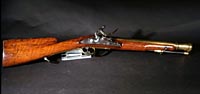
Blunderbuss
The Lewis and Clark expedition was in many ways an infantry company on the move, fully equipped with rifles of various kinds, muskets, and pistols. Among the firearms were two blunderbusses. Named after the Dutch words for "thunder gun," the blunderbuss was unmistakable for its heavy stock, short barrel, and wide-mouthed muzzle. Other expedition guns might be graceful in design and craftsmanship but the stout blunderbuss simply signified brute force and power. Lewis and Clark fired their blunderbusses as signs of arrival when entering Indian camps or villages.
Discovering Diplomacy
One of Lewis and Clark's missions was to open diplomatic relations between the United States and the Indian nations of the West. As Jefferson told Lewis, "it will now be proper you should inform those through whose country you will pass . . . that henceforth we become their fathers and friends." When Euro-Americans and Indians met, they used ancient diplomatic protocols that included formal language, ceremonial gifts, and displays of military power. But behind these symbols and rituals there were often very different ways of understanding power and authority. Such differences sometimes made communication across the cultural divide difficult and open to confusion and misunderstanding.
An important organizing principle in Euro-American society was hierarchy. Both soldiers and civilians had complex gradations of rank to define who gave orders and who obeyed. While kinship was important in the Euro-American world, it was even more fundamental in tribal societies. Everyone's power and place depended on a complex network of real and symbolic relationships. When the two groups met--whether for trade or diplomacy--each tried to reshape the other in their own image. Lewis and Clark sought to impose their own notions of hierarchy on Indians by "making chiefs" with medals, printed certificates, and gifts. Native people tried to impose the obligations of kinship on the visitors by means of adoption ceremonies, shared names, and ritual gifts.
When Thomas Jefferson sent Lewis and Clark into the West, he patterned their mission on the methods of Enlightenment science: to observe, collect, document, and classify. Such strategies were already in place for the epic voyages made by explorers like Cook and Vancouver. Like their contemporaries, Lewis and Clark were more than representatives of European rationalism.
They also represented a rising American empire, one built on aggressive territorial expansion and commercial gain.
But there was another view of the West: that of the native inhabitants of the land. Their understandings of landscapes, peoples, and resources formed both a contrast and counterpoint to those of Jefferson's travelers. This part of the exhibition presents five areas where Lewis and Clark's ideas and values are compared with those of native people. Sometimes the similarities are striking; other times the differences stand as a reminder of future conflicts and misunderstandings.
Making Chiefs
Lewis was frustrated by the egalitarian nature of Indian society: "the authority of the Chief being nothing more than mere admonition . . . in fact every man is a chief." He set out to change that by "making chiefs." He passed out medals, certificates, and uniforms to give power to chosen men. By weakening traditional authority, he sought to make it easier for the United States to negotiate with the tribes. Lewis told the Otos that they needed these certificates "In order that the commandant at St. Louis . . . may know . . . that you have opened your ears to your great father's voice." The certificate on display was left over from the expedition.
This image is not available online:
Speech to the Yellowstone Indians, 1806
Speech of Arikara chiefs, 1804
Manuscripts
Courtesy of the Missouri Historical
Society, St. Louis (44, 49)
Making Speeches
In their speeches, Lewis and Clark called the Indians "children." To explorers, the term expressed the relationship of ruler and subject. Clark modeled this speech to the Yellowstone Indians on one that Lewis gave to Missouri River tribes. In their speeches, the Indians called Lewis and Clark "father," as in this example made by the Arikira Chiefs. To them, it expressed kinship and their assumption that an adoptive father undertook an obligation to show generosity and loyalty to his new family. William Clark recorded this speech as it was made by the chiefs.
Making Kinship
In tribal society, kinship was like a legal system--people depended on relatives to protect them from crime, war, and misfortune. People with no kin were outside of society and its rules. To adopt Lewis and Clark into tribal society, the Plains Indians used a pipe ceremony. The ritual of smoking and sharing the pipe was at the heart of much Native American diplomacy. With the pipe the captains accepted sacred obligations to share wealth, aid in war, and revenge injustice. At the end of the ceremony, the pipe was presented to them so they would never forget their obligations. This pipe may have been given to Lewis and Clark.
Jefferson's Cipher
While Jefferson knew that for much of the journey he and his travelers would be out of touch, the president thought Indians and fur traders might carry small messages back to him. A life-long fascination for gadgets and secret codes led Jefferson to present Lewis with this key-word cipher. Lewis was instructed to "communicate to us, at seasonable intervals, a copy of your journal, notes & observations, of every kind, putting into cipher whatever might do injury if betrayed." The scheme was never used but the sample message reveals much about Jefferson's expectations for the expedition.
Gifts with a Message
Gift-giving was an essential part of diplomacy. To Indians, gifts proved the giver's sincerity and honored the tribe. To Lewis and Clark, some gifts advertised the technological superiority and others encouraged the Indians to adopt an agrarian lifestyle. Like salesmen handing out free samples, Lewis and Clark packed bales of manufactured goods like these to open diplomatic relations with Indian tribes. These beads came from Mitutanka, the village nearest to Fort Mandan. Jefferson advised Lewis to give out corn mills to introduce the Indians to mechanized agriculture as part of his plan to "civilize and instruct" them. Clark believed the mills were "verry Thankfully recived," but by the next year the Mandan had demolished theirs to use the metal for weapons.
Displays of Power
In situations when ceremonies, speeches, and gifts did not work, both the Corps and the Indians gave performances that displayed their military power. The American soldiers paraded, fired their weapons, and demonstrated innovative weaponry. The Indians used war clubs, like this Sioux club, in celebratory scalp dances. Three decades later, Swiss artist Karl Bodmer accompanying naturalist Prince Maximillian, retraced Lewis and Clark's trek on the Missouri River and vibrantly recorded a similar scene in the print displayed above.
Jefferson's Speech to a Delegation of Indian Chiefs
Indian delegations had long been part of European diplomacy with native people, and they came to play an increasingly important role in U.S. Indian policy as well. Even before leaving St. Louis, Lewis and Clark began organizing delegations to visit the new "great father" in Washington. Jefferson's speech to a group of chiefs from the lower Missouri River is an arresting combination of friendship, promises of peaceful relations in a shared country, and thinly veiled threats if Indians rejected American sovereignty. Reminding the chiefs of the changes in international diplomacy after the Louisiana Purchase, Jefferson insisted that "We are now your fathers; and you shall not lose by the change." But behind all the promises of a shared future was an unmistakable threat. As the president said, "My children, we are strong, we are numerous as the stars in the heavens, & we are all gunmen."
Indian Speech to Jefferson
A delegation of chiefs from western tribes was sent by Lewis to Washington, D.C. President Jefferson welcomed them with words of peace and friendship. But if President Jefferson expected his native visitors to quietly accept their status as "children" in the new American order, he was mistaken. In their speech to Jefferson, the chiefs raised two important concerns: the troubled economic relations between native people and the federally operated trading posts and the rising tide of violence Indians suffered at the hands of white settlers on the Missouri River frontier. These chiefs were determined to speak the truth "to the ears of our fathers." In return, they expected that government officials would "open their ears to truth to get in."
Geography
In the exploration instructions prepared for Lewis, Jefferson directed that his explorers record "the face of the country." Geography, especially as recorded on maps, was an important part of the information collected by the Corps of Discovery. In planning the expedition, Lewis and Gallatin collected the latest maps and printed accounts portraying and describing the western country. This visual and printed data was incorporated into a composite document--the Nicholas King 1803 map--which the expedition carried with them at least as far as the Mandan villages. As Lewis and Clark traversed the country, they drew sketch maps and carefully recorded their astronomical and geographic observations. Equally important, they gathered vital knowledge about "the face of the country" from native people. During winters at Fort Mandan on the Missouri in 1804-1805 and at Fort Clatsop on the Pacific Coast in 1805-1806 the explorers added new details from their sketch maps and journals to base maps depicting the course of the expedition. The first printed map of the journey did not appear until 1814 when Nicholas Biddle's official account of the expedition was published in Philadelphia and London.
Euro-American explorers were not the only ones to draw maps of the western country. As every visitor to Indian country soon learned, native people also made sophisticated and complex maps. Such maps often covered thousands of miles of terrain. At first glance Indian maps often appear quite different from those made by Euro-Americans. And there were important differences that reflected distinctive notions about time, space, and relationships between the natural and the supernatural worlds. William Clark was not the only expedition cartographer to struggle with those differences. But the similarities between Indian maps and Euro-American ones are also worth noting. Both kinds of maps told stories about important past events, current situations, and future ambitions. Both sorts of maps used symbols to represent key terrain features, major settlements, and sacred sites. Perhaps most important, Euro-Americans and Native Americans understood that mapping is a human activity shared by virtually every culture.
Nicholas King's 1803 Pre-Expedition Map
In March 1803, War Department cartographer Nicholas King compiled a map of North America west of the Mississippi in order to summarize all available topographic information about the region. Representing the federal government's first attempt to define the vast empire later purchased from Napoleon, King consulted numerous published and manuscript maps. The composite map reflects Jefferson and Gallatin's geographical concepts on the eve of the expedition. It is believed that Lewis and Clark carried this map on their journey at least as far as the Mandan-Hidatsa villages on the Missouri River, where Lewis annotated in brown ink additional information obtained from fur traders.
Source Map for the Bend of the Missouri River
One of the sources for Nicholas King's 1803 map was this sketch of the Great Bend of the Missouri River (north of present-day Bismarck, North Dakota). Copied by Lewis from a survey for the British North West Company by David Thompson, this map provided the exact latitude and longitude of that important segment of the Missouri. Thompson, traveling overland in the dead of winter, spent three weeks at the Mandan and Pawnee villages on the Missouri River, calculating astronomical observations. He also recorded the number of houses, tents, and warriors of the six Indian villages in the area.
Fort Mandan Map
Throughout the winter of 1804-1805 at Fort Mandan, William Clark drafted a large map of the West --what he called "a Connection of the country." That map, recopied several times by Nicholas King, provided the first accurate depiction of the Missouri River to Fort Mandan based on the expedition's astronomical and geographical observations. Drawing on "information of Traders, Indians, & my own observation and idea," Clark sketched out a conjectural West--one characterized by a narrow chain of mountains and rivers with headwaters close one to the other, still suggesting an easy water passage to the Pacific Coast.
Indian Map of Columbia and Snake Rivers
Although there are journal notes stating that Indians provided geographical information for Lewis and Clark and drew maps on animal skins or made rough sketches in the soil, no original examples survive. However, there are several collaborative efforts in which members of the Corps redrew Indian sketches often combining their own observations with Indian information. This sketch map found in one of William Clark's field notebooks is a good example of a map derived from Indian information. It is a diagram of the relative location of tributaries of the Columbia and Snake (Lewis) rivers in present-day eastern Washington and Oregon.
Field Maps of the Fort Clatsop Area
This pair of maps is from a collection of manuscript field maps drafted by Clark as the Corps descended the Columbia River and wintered on the Pacific Coast at Fort Clatsop. On the left, Clark drew a rough sketch of the mouth of the Columbia River, oriented with south at the top of the sheet. The other is one of the cruder examples of a map derived from Indian information, with Clark noting "This was given by a Clott Sopp Indn." It shows a small portion of the Pacific Coast and locates several tribes and villages.
Sitting Rabbit's Map of the Missouri River
Displayed here is a portion of a 1906-1907 map depicting the Missouri River through North Dakota to the mouth of the Yellowstone River. It was prepared by Sitting Rabbit, a Mandan Indian, at the request of an official of the State Historical Society of North Dakota. Although it uses a Missouri River Commission map as its base, the content provides a traditional Indian perspective of the river's geography, especially noting former Mandan village sites with earthen lodges. The portion of the river shown here corresponds to the same stretch of river delineated on Clark's route map (below).
Missouri Route Map near Fort Mandan
Throughout the expedition, William Clark prepared a series of large-scale route maps, with each sheet documenting several days' travel. On these sheets he recorded the course of rivers navigated, mouths of tributary streams, encampments, celestial observations, and other notable features. Big River on Sitting Rabbit's map (above) is identified as Cannon Ball River on Clark's map and Beaver Creek is recorded as Warraconne River or "Plain where Elk shed their horns," by Clark.
Fort Clatsop Map
This post-expeditionary map prepared by Washington, D.C., cartographer Nicholas King, probably in 1806 or 1807, most likely incorporates information from a map prepared by Lewis and Clark in February 1806 at Fort Clatsop on the Oregon coast. Although the original map no longer exists, such a map is mentioned in the expedition's journals. Using King's 1805 base map, which records information observed as far as Fort Mandan, this present copy adds geographical observations from Fort Mandan to the west coast, as well as data from the return trip.
Clark's Map of Midwestern Indian Settlements
Following his appointment as governor of the Missouri Territory in 1813, William Clark sketched this map of various Indian tribes and villages throughout the Missouri and Illinois territories, showing the locations of numerous forts and settlements. He prepared it in response to British incursions on the frontier during the War of 1812, when it was feared that the Indians, many of them allied with the British, would attack white settlements. The map also reflects Clark's continuing post-expedition interest in Indian activities having been appointed superintendent of Indian affairs at St. Louis in 1807.
Frazer's Post-Expedition Map
Private Robert Frazer was the first member of the Lewis and Clark party to announce publication of an expedition journal. His account never reached print, and the original journal was lost. This manuscript map is the only remnant of that initial publishing attempt. Since Frazer had little or no knowledge of surveying or natural sciences, the map is a strange piece of cartography. He traces the expedition's route, but continues to depict older views of the Rocky Mountains and western rivers. Sometimes ignored, the Frazer map was one of the first to reveal the course of the journey and some of its geographic findings.
First Published Map of Expedition's Track
This was the first published map to display reasonably accurate geographic information of the trans-Mississippi West. Based on a large map kept by William Clark, the engraved copy accompanied Nicholas Biddle's History of the Expedition (1814). As the landmark cartographic contribution of the expedition, this "track map" held on to old illusions while proclaiming new geographic discoveries. Clark presented a West far more topographically diverse and complex than Jefferson ever imagined. From experience, Clark had learned that the Rockies were a tangle of mountain ranges and that western rivers were not the navigable highways so central to Jefferson's geography of hope
History of the Expedition
After Lewis's death in September 1809, Clark engaged Nicholas Biddle to edit the expedition papers. Using the captains' original journals and those of Sergeants Gass and Ordway, Biddle completed a narrative by July 1811. After delays with the publisher, a two-volume edition of the Corps of Discovery's travels across the continent was finally available to the public in 1814. More than twenty editions appeared during the nineteenth century, including German, Dutch, and several British editions.
Calculating Distance
In order to make astronomical observations that would aid in calculating distances, the Corps took a sextant on their journey. On July 22, 1804, while the expedition was above the mouth of the Platte River in eastern Nebraska, Lewis gave a detailed description of the operation of the sextant and other tools that reveals his struggle to use the complicated instruments. A select number of books were taken on the expedition including British astronomer Nevil Maskelyne's Tables Requisite to be Used with the Nautical Ephemeris for Finding the Latitude and Longitude at Sea.
NOTE THE NATIVE AMERIAN VIEW OF ANIMALS AS TEACHERS OF MORAL LESSONS AND OF THEIR FUNCTION AS INTERMEDIARIES
Animals
Jefferson subscribed to the eighteenth-century Enlightenment notion that assembling a complete catalog of the Earth's flora and fauna was possible. In his instructions, he told Lewis to observe "the animals of the country generally, & especially those not known in the U.S." The Corps of Discovery was the first expedition to scientifically describe a long list of species. Their journals, especially those kept by Lewis, are filled with direct observations of the specimens they encountered on the journey. Through objective measurements and anatomical descriptions, they defined various species previously unknown to Euro-Americans.
Lewis's woodpecker
The woodpecker displayed above may be the only specimen collected during the Lewis and Clark expedition to survive intact. Lewis first saw the bird on July 20, 1805, but did not get a specimen until the following spring at Camp Chopunnish on the Clearwater River in Idaho. Lewis's description of the bird's belly is still accurate when examining the specimen today: "a curious mixture of white and blood red which has much the appearance of having been artificially painted or stained of that colour."
Indians studied animal behaviors to understand moral lessons. Animals were beings addressed respectfully as "grandfather" or "brother." Because animals intersected the worlds of the sacred and the profane, Indians regarded them as intermediaries between the human and spiritual realms.
Observing "the animals of the country generally"
Lewis covered pages with descriptions of animals and plants during the winter of 1805-1806. This particular journal kept during that period contains abundant zoological notes in Lewis's hand. The journal is open to a description of the Corps first encounter with a white-tailed jack rabbi--an animal considered so impressive that both Lewis and Clark wrote extensive descriptions of it. On selected occasions both captains illustrated their notes. In the reproduction above Clark sketched the now-endangered condor. Lewis had correctly observed in his journal: "I bleive this to be the largest bird of North America."
Representing Beings
The Indian sense of "personhood" extends far beyond the western conception of human beings. In Indian culture animal people, plant people, sky peopleCall are beings in their own right. Indian art portrays a being's inner essence, not its physical form. The Columbia River artist who created this twined circular basket decorated it with images of condors, sturgeons, people, and deer -- abstractions that are given equal importance in the woven pattern. This nineteenth-century Sioux clay and wood pipe portrays a buffalo, whose spirit, or Tananka, cares for children, hunters, and growing things. It may have be created as a presentation pipe.
Hunting Bear
Patrick Gass was one of the three sergeants in the Corps of Discovery. His account, first printed in 1807, was the only one available to curious readers until the official publication appeared in1814. This Gass edition contains six woodcuts, two of which depict encounters with bears. The image above may have been based on Corps member Hugh McNeal's experience on July 15, 1806. Lewis records: ". . .and with his clubbed musquet he struck the bear over the head and cut him with the guard of the gun and broke off the breech, the bear stunned with the stroke fell to his ground. . .this gave McNeal time to climb a willow tree."
The Power of the Bear
Artist George Catlin painted the scene of a dance held in preparation for a traditional Sioux bear hunt in 1832. These dances were performed in order to communicate with "the Bear Spirit." According to Catlin, the Sioux believe this spirit "holds somewhere an invisible existence that must be consulted and conciliated." This clay Sioux pipe bowl probably depicts the bear's role as teacher and transmitter of power.
Dressed in Courage
In both Euro-American and native cultures, clothing communicated messages about the wearer's biography, rank, and role in society. In both cultures, a warrior's clothing was his identity and men entered battle dressed in regalia that displayed their deeds and status. Symbolic insignia revealed a complex code about who a man was and what he had accomplished. But differences did exist. For instance, Plains Indian men wore clothing that incorporated symbols of their spirit visions, tribal identity, and past deeds as manifestations of the spiritual powers that helped them in battle. European soldiers wore similar symbols but as a way to display and inspire uniform loyalty to their nation.
Wearing Achievement
The U.S. Army lavished effort on the details of uniforms, increasing the psychological impact on the wearer and his opponent. Military insignia were designed to prevent any ambiguity about chains of command, so that a soldier could instantly tell whom to obey. The U.S. Army was so small in 1804 that no complete uniforms survive. This reproduction portrays a captain in the full-dress uniform of the 1st U.S. Infantry Regiment, to which Lewis belonged. The "Kentucky" rifle shown below--a .45 caliber flint lock--was passed down through William Clark's family.
The Plains Warrior
A Plains Indian warrior relied on personal power in battle, and his dress incorporated symbols of his spirit visions, his tribal identity, and his past deeds. The leader of a war party often wore a painted shirt that detailed his war record. On such shirts made from animal skins, the contours of the pelt were left intact in the belief that the animal would lend its qualities to the wearer. The most powerful shirts were fringed with locks of human hair provided by relatives and supporters to represent the man's responsibilities to his relations. This shirt, probably Blackfeet, has buffalo-track symbols on the neck flap that evoke the power of the bison to aid the warrior in battle.
Images of Heroism
Plains Indian men wore painted skin robes that told of their achievements. This image of Shoshone Chief Washakie's war robe shows a series of diagrammatic battle scenes. Here, events happen not in a landscape but in a symbolic realm of deeds. Depictions of his enemies are not individualized, but are instead given costumes, hairstyles, or equipment that represent tribal affiliation, society membership, and past deeds. Warriors are sometimes represented by disembodied guns or arrows
The Ideal Military Hero
In 1759, at the height of the French and Indian War, General Wolfe led a British-American assault on the French outside Quebec. The print, based on a painting by Benjamin West, shows the wounded general dying just as a messenger brings news that the enemy is retreating. In the moment of both victory and death, Wolfe achieves transcendent glory. His uplifted eyes suggest both sacrifice for the nation and triumph over death--not through faith but through fame. This was an idealized image to which military men of Lewis and Clark's generation aspired.
Coyote Headdress
Coyote, the mythic trickster of the Plains Indians, was the protector of the scouts who spied on the enemy for a war party. This nineteenth-century Teton headdress from the Standing Rock Reservation in North Dakota was meant to summon and symbolize Coyote's craftiness.
Spontoon and Gorget
The spontoon, a long wooden shaft with a spear at one end, became popular with the American army during the Revolutionary War. Although it was required equipment that signified an officer's rank, these pikes were commonly abandoned for more practical weapons in battle. Lewis used his as a walking stick, a grizzly-bear spear, and a gun rest, but never to rally troops in battle. The origins of the gorget can be traced to the chivalric armor. American army officers wore these ceremonial insignia high on the chest. Lewis presented gorgets (which he called "moons") to Indian leaders to symbolize rank.
Bear Claw Necklace
To wear a bear claw necklace was a mark of distinction for a warrior or a chief, and the right to wear it had to be earned. These powerful symbols were a part of the culture of the Great Lakes, Plains, and Plateau tribes. On August 21, 1805, Lewis wrote in this journal that Shoshone "warriors or such as esteem themselves brave men wear collars made of the claws of the brown bear. . . . These claws are ornamented with beads about the thick end near which they are pierced through their sides and strung on a throng of dressed leather and tyed about the neck . . . . It is esteemed by them an act of equal celebrity the killing one of these bear or an enimy."
Plants
In his instructions to Lewis, Jefferson directed the party to observe and record "the soil & face of the country, it's growth & vegetable productions, especially those not of the U.S. . . . the dates at which particular plants put forth or lose their flower, or leaf . . . ." The study and collection of plants was one of Jefferson's life-long pursuits. When he instructed the Corps in their approach to cataloging the country's flora, Jefferson again set the pattern for subsequent explorations. Jefferson, however, was not purely motivated by science; plants thought to have medicinal properties, like tobacco and sassafras, were important to the U.S. economy. As the Napoleonic Wars swept Europe and affected exports to the United States, there was a call to reduce America's dependence on foreign medicine and find substitutes on native soil.
Indians and Europeans had been exchanging knowledge about curing and health for three centuries, yet they still held very different beliefs. Indian doctors focused on the patient's relationship to the animate world around him. Euro-American doctors saw the body as a mechanical system needing regulation. Meriwether Lewis, instructed by America's foremost physician Dr. Benjamin Rush, University of Pennsylvania botanist Benjamin Barton, and his own mother, a skilled herbalist, was to serve as the Corps doctor, but William Clark also became adept in treating various illnesses. Though Clark rejected Indian explanations, he often turned to Indian techniques when members of his own party became ill.
Curing the Corps
Lewis and Clark were not persuaded by Indian explanations of why illness occurred but often used Indian cures in preference to their own. The Corps began its journey stocked with traditional western medicinal treatments and tools. Lewis used lancets to let out blood in such dangerous conditions as heat exhaustion and pelvic inflammation, and tourniquets to stop blood flow. Bleeding was thought to relieve congestion in internal organs. Lewis originally thought he would need three syringes for enemas but settled for one. There is no further mention of its use. Laxatives, derived from plant sources, were also used to purge the body of impurities.
Rules of Health
Thomas Jefferson asked Benjamin Rush, a noted physician and professor of medicine at the University of Pennsylvania, to "prepare some notes of such particulars as may occur in his journey & which you think should draw his attention & enquiry." Dr. Rush restricted his advice to practical hints for maintaining health in the field--some of it unwelcome like using alcohol for cleaning feet instead of for drinking. Many Americans did not trust professional medicine and instead used folk cures like these written down by Clark after the expedition. Many folk cures originally came from Indian sources.
Summoning the Spirits
An Indian doctor's job was to identify the being that had caused an illness, then overcome or placate it. An Indian patient lived in an animate world, surrounded by entities who could make him ill. Medicinal herbs and roots were powdered and mixed in a mortar like this one from the Northern Plains. Drums and herbs were used to summon helpful spirits as aids in healing. Fragrant herbs pleased and attracted good influences and drove away evil ones. This sweetgrass braid was used as an incense to purify implements, weapons, dwellings, and people.
A Botanical Specimen
While admitting that Lewis was "no regular botanist," Jefferson did praise "his talent for observation." And on June 11, 1806, during an extended stay with the Nez Perce people, Lewis showed that talent. Camas, sometimes known as quamash, was an important food plant for the Nez Perces. Lewis carefully described the plant's natural environment, its physical structure, the ways women harvested and prepared camas, and its role in the Indian diet. Some days later Lewis gathered samples of camas for his growing collection of western plants.
Flora Americae Septentrionalis
Frederick Pursh, an emigrant from Saxony who worked with botanist Benjamin Smith Barton in Philadelphia, published the first botanical record of the Lewis and Clark expedition. Pursh received a collection of dried plants from Lewis, which he classified and incorporated into his Flora Americae Septentrionalis. The volume is open to Clarkia pulchella, a member of the evening primrose family, which Pursh named in honor of William Clark. Pursh took some of the Lewis and Clark specimens to London to finish the book, including the silky lupine specimen to the far left.
Root Digging Bag
Among the Nez Perce, only women harvested plant foods. A man doing so risked derision and contempt. A Nez Perce woman's year was structured around plants. As each new food plant matured, its arrival was welcomed in a first fruits feast. Root bags were used in gathering, cooking, and for storage. An industrious woman could dig eighty or ninety pounds of roots in a day.
A Gathering Basket
The cedar bark basket was used across the Plateau for gathering berries, nuts, and roots. Bark baskets could be made easily when a person came across some forest food by stripping off a piece of cedar bark and folding it.
A Sally Bag
Plateau tribes gathered wild hemp and beargrass, then traded it to the Wishram and Wasco Indians at The Dalles in Oregon, the dividing line between North Coast and Plateau Indians. The traded raw materials would then be made into finished products like this sally bag, used for packaging food.
Storing Roots
Among the Shoshone, Lewis noted that dried roots were stored by being "foalded in as many parchment hides of buffaloe." Hide bags, like the one on display, were made by cleaning and sizing rawhide so that it had a smooth, paintable surface. This bag is decorated in a distinctive Plateau style.
Sources for the Lewis & Clark Expedition Maps of 1803 and 1814
The two key maps that bracket the Lewis and Clark expedition are the Nicholas King map of 1803 and the Track Map of 1814.
Nicholas King drew upon the most current information in creating his map. This presentation shows how existing maps were used to form King's map, which it is believed, Lewis and Clark took on their journey.
The 1814 Track Map was the landmark product of the expedition. Based on a large map kept by William Clark in his St. Louis office, this map shows the geographic exploration made by Lewis and Clark. It was part of the expedition's official publication.
http://www.loc.gov/exhibits/lewisandclark/lewis-before.html
When Christopher Columbus, sailing for the king and queen of Spain in the 1490s, explored what today is known as the West Indies, the central American coast, and the northern coast of South America, the existing European world view began to change in dramatic and sometimes unpredictable ways. Other explorers followed including Amerigo Vespucci, who identified these lands as a separate continent, not as islands or peninsulas attached to eastern Asia. Utilizing Vespucci's travel accounts, German geographer Martin Waldseemüller depicted this new continent on a large world map in 1507, naming it "America" in Vespucci's honor.
Throughout the sixteenth and seventeenth centuries, Europeans explored, mapped, and colonized what they now called "America." Although contradictory images of North America appeared on European world maps, the outline of the continent began to take shape.
Martin Waldseemüller (c.1470-1518/21) Universalis Cosmographia Secundum Ptholomaei Traditionem et Americi Vespucii Alioruque Lustrationes
[Map of the world naming "America"],
Strassburg: 1507
Woodcut map, with emendations
Geography and Map Division (1) Recognizing and Naming a New Continent
Martin Waldseemüller's 1507 world map grew out of an ambitious project in St. Dié, France, during the first decade of the sixteenth century, to document and update new geographic knowledge derived from the discoveries of the late fifteenth and the first years of the sixteenth centuries. Waldseemüller's large world map was the most exciting product of that research effort, and included data gathered during Amerigo Vespucci's voyages of 1501-1502 to the New World. Waldseemüller christened the new lands "America" in recognition of Vespucci's understanding that a new continent had been uncovered as a result of the voyages of Columbus and other explorers in the late fifteenth century. This is the only known surviving copy of the first printed edition of the map, which, it is believed, consisted of 1,000 copies.
Waldseemüller's map supported Vespucci's revolutionary concept by portraying the New World as a separate continent, which until then was unknown to the Europeans. It was the first map, printed or manuscript, to depict clearly a separate Western Hemisphere, with the Pacific as a separate ocean. The map represented a huge leap forward in knowledge, recognizing the newly found American landmass and forever changing the European understanding of a world divided into only three parts--Europe, Asia, and Africa.
Cartographic Formation of The North American Continent
This presentation depicts the emerging European world view of North America, which began to change upon the dissemination of reports from the voyages of Christopher Columbus. Other explorers sailed forth, including Amerigo Vespucci who identified these lands as a separate continent. Utilizing Vespucci's travel accounts, German geographer Martin Waldseemüller depicted this new continent on a large world map in 1507, naming it "America" in Vespucci's honor.
Throughout the sixteenth and seventeenth centuries, Europeans explored, mapped, and colonized what they now called "America." Although contradictory images of North America appeared on European world maps, the outline of the continent began to take shape.
http://www.loc.gov/exhibits/lewisandclark/lewis-before.html
The Spanish Entrada into the Southwest
Spanish exploration and settlement in the present-day American Southwest can be traced back to the early sixteenth century. By the last half of the eighteenth century Spanish soldiers and missionaries had made their way as far as San Antonio, Santa Fe, Tucson, and San Francisco. Several expeditions, including those of Father Eusebio Kino, José de Urrútia and Nicolás de Lafora, and Father Silvestre Vélez de Escalante, had explored large parts of the southwest. However, the geography of this region remained virtually unknown outside the Spanish empire, since the maps and accounts of Spanish exploration remained in manuscript and were not published. Not until the beginning of the nineteenth century, when the noted German geographer Alexander von Humboldt visited Mexico City and was given access to the Spanish archives, did this information become more widely available. Although von Humboldt's map of Mexico was not published until 1811, he did visit Washington, D.C., in 1804, and shared his preliminary findings with President Jefferson and Secretary of the Treasury Albert Gallatin. Knowing that such geographic knowledge would be useful in determining the boundaries of the new Louisiana Purchase, Jefferson and Gallatin were keenly interested in von Humboldt's depiction of the Spanish empire in the southwest.
Beyond the Allegheny Mountains
Thomas Jefferson, Meriwether Lewis, and William Clark were all culturally and intellectually Virginians. As the leading figures in what became the Lewis and Clark Expedition, they were steeped in a colonial legacy that optimistically looked westward in anticipation of exploiting the treasures of an Eden that lay beyond the Allegheny Mountains. In the earliest stages of Chesapeake tidewater settlement, Virginia, like other colonies, had an imperial mentality and vision that encompassed the entire breadth of the continent. During the last half of the eighteenth century Virginia's leaders, as well as those in other colonies, began to consider more practical means to reach Eden beyond the mountains. Virginians, including Jefferson and George Washington, believed that by building canals and improving navigation on the colony's major rivers--the James and the Potomac--they could defeat similar schemes that centered on the Hudson River and New York City. And at its grandest, the Virginia imperial vision also reached out to the Ohio, Mississippi, and Missouri rivers. Jefferson's Notes on the State of Virginia confidently declared that such rivers could extend the reach of an American empire beyond the mountains, perhaps even to the western sea.
The Pacific Beyond the Alleghenies
Originally published in 1651 by John Farrer, a representative of the Virginia Company, this 1667 edition was issued by Farrer's daughter, Virginia. It perpetuates the notion that the Pacific Ocean lay just across the Allegheny Mountains--separated by a narrow strip of land that could be traveled in only "ten days marche." At this time, the actual distance between the two oceans was unknown, but the intention was to link Sir Francis Drake's 1577 landing in New Albion (Point Reyes, California) with the recently settled Virginia colony, thereby substantiating British claims to the breadth of the continent.
Escalante Expedition Diary
Copied by a lieutenant of the Spanish Royal Corps of Engineers, this volume includes the diary of the expedition conducted by the Franciscan priests Silvestre Veléz de Escalante and Francisco Dominguez. It records their route that started out from Sante Fe on July 29, 1776, making a circuit through what is now Colorado, Utah, and Arizona. The diary describes geographic features and mentions passing the ancient cliff dwellings of Mesa Verde in Colorado
Seeking Information on the Southwest
President Jefferson sought information on the territory west of the Mississippi River from a wide variety of sources. When Baron Alexander von Humboldt visited Washington in 1804, after his South American tour, Jefferson took the opportunity to gather information about the newly acquired Louisiana territory. In this note to von Humboldt, Jefferson was particularly interested in the population "of white, red, or black people."
A Cartographic Myth Dispelled
Father Eusebio Francisco Kino, an Italian-born Jesuit missionary, explored the area around Tucson from 1687 to 1701, traveling as far as the mouth of the Colorado River. He proved that California was not an island, a myth that had endured for almost a century. Although his cartographic findings first appeared in 1705, a slightly later version of his map was published in a German missionary periodical on display here. This map shows the Gila River flowing into the Colorado directly above its mouth and extensive settlements in northern New Spain.
Spanish Military Survey of Southwest Borderlands
This detailed map of the Internal Provinces of New Spain (northern Mexico and southwestern United States) reflects the Spanish government's concern during the second half of the eighteenth century about frontier defenses, especially in response to American Indian attacks and the potential movement of European enemies into the region. The 1766-1768 survey involved a two-year, 6,000 mile trek extending from the Gulf of California to the Red River in Louisiana. Since this map was never published, British Americans were not aware of the extent of geographical and ethnological information known about the Spanish frontier.
Escalante Reaches the Rockies
A party of ten, led by Franciscan Fathers Francisco Atanasio Dominguez and Silvestre Vélez de Escalante departed Santa Fe in late July 1776, and returned to that location on January 2, 1777, as part of a failed effort to link Santa Fe with the new Spanish settlements along the Pacific Coast. The expedition did obtain substantially more knowledge of the regions north, northwest, and west of Santa Fe than any previous party, penetrating further into the unknown central Rockies. The manuscript map displayed above, made by expedition cartographer Bernardo Miera y Pacheco, reveals Spain's northernmost efforts to explore the interior of western North America.
Exploration of the Missouri River
For nearly 150 years, beginning in the early seventeenth century until the middle of the eighteenth century, France claimed a major portion of North America extending in an arc from the Gulf of Saint Lawrence to New Orleans. Working with Indians to exploit the fur trade, the French explored and mapped much of the continent's interior east of the Rocky Mountains, focusing on the St. Lawrence River, the Great Lakes, and the lower Mississippi. Although the French lost this territory to the British following the French and Indian War in 1763, small, scattered French settlements persisted along these major water routes. For the Lewis and Clark expedition no western settlement was more important than the French settlement of St. Louis. Just becoming the "Gateway to the West," St. Louis was home to traders, merchants, and boatmen who knew the Missouri as far up as present-day North Dakota. Their everyday knowledge of the river proved invaluable as the American expedition made its way west. And it was in St. Louis where the American explorers benefited from the maps and exploration experiences of men like the Scottish trader James Mackay and the Welsh adventurer John Thomas Evans.
"Notes on Indian Tribes"
During the course of several ventures up the Missouri River as far as the Mandans in the 1780s and 1790s, James Mackay, a Scottish trader and explorer sponsored by the Spanish government, and his assistant, John Thomas Evans, a Welshman, had accumulated vital information about the tribes of the Missouri River valley and even planned their own venture to the Pacific Ocean. While at Camp Dubois in Illinois during the winter of 1803-1804, Lewis and Clark acquired some of this knowledge through talking with Mackay and examining the trader's notes, journal extracts, and maps.
British Passage to the Pacific
The last part of the North American coastline to be explored and mapped by Europeans was the northern portion extending from the Pacific Northwest around Alaska and along the shores of the Arctic Ocean. Much of the energy for such explorations came from the persistent search for a northwest passage, the elusive water route from Atlantic to Pacific. During the last half of the eighteenth century, the Russian fur traders and imperial officials began to take an interest in Alaska while the British focused on the regions of Hudson's Bay, the Arctic Ocean, and the Pacific Northwest. The new geographic knowledge of interior North America provided by the fur trading activities of the Hudson's Bay Company, the North West Company, the coastal explorations of Spanish and British navigators including James Cook and George Vancouver, and the transcontinental trek of Alexander Mackenzie were incorporated into the 1802 map of North America published by the noted British geographer Aaron Arrowsmith. This map and its depiction of British discoveries in the northwestern portion of the continent were among the materials that proved crucial to Jefferson in defining the Lewis and Clark expedition.
Captain Cook and Nootka Sound
Sailing under the British flag with the intention of locating the western gateway to the fabled Northwest Passage, Captain James Cook devoted his third and final voyage to exploring the Pacific Basin and the northwest coast of North America from Oregon to Alaska. His account of the voyage included illustrations like this view of the native "habitations" of Nootka Sound on the west coast of Vancouver Island in present-day British Columbia. Like expeditions to follow, Cook was instructed to observe the flora, fauna, and geology he encountered and ". . .to describe them as minutely, and to make as accurate drawings of them, as you can.
First Transcontinental Travel Account
In 1793 North West Company trader Alexander Mackenzie became the first European explorer to cross the American continent north of Mexico, following a route through northern Canada. His published journal includes several Indian vocabularies as well as an early history of the fur trade. It was reprinted in twenty-six editions in four languages. After reading Voyages from Montreal in the summer of 1802, Thomas Jefferson accelerated plans for what became the Lewis and Clark Expedition. P. Conde's frontispiece engraving is based on the only known authentic portrait of Mackenzie.
Louisiana Purchase
Following the French and Indian War (1754-1763), France lost its possessions in North America. Spain acquired the former French territory of Louisiana (French lands west of the Mississippi) and New Orleans. Britain added the St. Lawrence Valley, along with the lands north of the Great Lakes and east of the Mississippi, to its well-established Atlantic empire. At the conclusion of the American Revolution in 1783, the new United States gained not only the British territory that constituted the original thirteen colonies but also the lands west of the Alleghenies, with the Mississippi River serving as the new nation's western boundary.
For American farmers intent on selling their produce down the Mississippi River, New Orleans was a port of vast importance. New Orleans remained under Spanish control, but American merchants did have the right of free passage on the Mississippi River and the use of the port without paying heavy customs duties. However, free navigation on the river was threatened when Napoleon secretly regained control of New Orleans and the lands west of the Mississippi. In an attempt to secure access to New Orleans, Thomas Jefferson directed Robert R. Livingston, U. S. Minister to France, and American diplomat James Monroe to negotiate the purchase of New Orleans and the Floridas for $10,000,000. Surprisingly, Napoleon not only agreed to sell New Orleans but also offered all of Louisiana for $15,000,000. The Americans quickly accepted the deal, thereby doubling the size of the nation.
The Purchase of Louisiana
In his letter to James Madison, James Monroe, U.S. special envoy, explains why he and Robert R. Livingston, America's minister to France, were obliged to purchase "the whole" of Louisiana. Monroe and Livingston later quarreled over who deserved credit for the acquisition of the Louisiana Territory. Monroe complained to Madison in this letter that the "most difficult vexations and embarrassing part of my labors has been with my associate." Monroe's role in the acquisition propelled him into contention for the presidency in 1808.
Treaty with France to Acquire Louisiana
After the Revolutionary War, the U.S. acquired British lands up to the Mississippi River. But the Spanish, who obtained the lands west of the Mississippi from France, barred American access to the river and the port of New Orleans. Only in 1795, by the Pinckney Treaty, did Spain allow American farmers and merchants the right to deposit and export goods on the Mississippi. This arrangement was jeopardized by France's secret acquisition of Louisiana. On learning that Napoleon, threatened by wars in Haiti and elsewhere, might sell Louisiana, Jefferson sent his emissaries to France to conclude the purchase. Above is James Monroe's copy of the treaty he negotiated for the United States.
AFTER LEWIS AND CLARK
http://www.loc.gov/exhibits/lewisandclark/lewis-after.html
During the first decade of the nineteenth century, the geographic image of western North America began to change dramatically. Based on the observations of Lewis and Clark, information gathered from native people, and Clark's own cartographic imagination, this image evolved from an almost empty interior with a hypothetical single mountain range serving as a western continental divide, to an intricate one showing a tangle of mountains and rivers. A continent that had once seemed empty and simple was now becoming full and complex.
It would take another fifty years after Lewis and Clark to complete the cartographic image of the West we know today. Other explorers and map makers followed, each revealing new geographic and scientific details about specific parts of the western landscape. But this revealing process was not a simple one. New knowledge did not automatically replace old ideas; some old notions--especially about river passages across the West--persisted well into the century. In the decades after Lewis and Clark the company of western explorers expanded to include fur traders, missionaries, and government topographers, culminating in the 1850s with the Army's Corps of Topographical Engineers surveying the southwestern and northwestern boundaries of the United States as well the potential routes for a transcontinental railroad. By the time of the Civil War, an ocean-to-ocean American empire with borders clearly defined was a fact of continental life.
The Journeys of Zebulon Montgomery Pike
In mid-July 1806 Lewis and Clark were on their way back from the Pacific. At the same time young army Lieutenant Zebulon Montgomery Pike left St. Louis with twenty-three men to reconnoiter the Spanish borderlands. Unlike the other expeditions commissioned by Jefferson, Pike did not travel by the command of the president. Instead, he took his orders from General James Wilkinson, governor of the Louisiana Territory and sometime secret agent for the Spanish. Pike carried out two expeditions for Wilkinson. The first (August 1805-April 1806) took him up the Mississippi River into present-day Minnesota. The second expedition began in July 1806 and drew to a close in late June 1807. As drafted by Wilkinson, Pike's instructions took the explorer into lands that were part of the Spanish empire. And in February 1807, near present-day Alamosa, Colorado, Spanish forces took Pike and his men into custody. Pike was a spy but just who he was spying for remains an open question. Pike's account of his southwestern adventures, published in 1810, drew additional attention to the region and its possible future as part of an expanding American empire.
Pike's Field Notes
This small notebook, which was among the papers confiscated from Zebulon Pike during his captivity in Mexico in 1807 and returned to the State Department in 1910, includes sketch maps and field observations from 1805-1807. It includes data from his expeditions along the upper Mississippi and into the Spanish borderlands. On the pages displayed above, dated September 8 through September 25, 1805, Pike recorded distances and observations as his party traveled along the Mississippi River. The entries conclude when the expedition reached the Falls of St. Anthony in present-day Minneapolis.
The "Santa Fe Trail"
This small sketch map, with west located at the top, is reportedly the first American map depicting the Santa Fe Trail. Although the map is in Pike's hand, it does not depict the route he traversed but was probably prepared as a reference map showing a 1797 trek by three French traders, operating out of the St. Louis area, from the juncture of the Platte and Missouri Rivers to Santa Fe (identified as St. Affee at the top of the page). When Pike was detained in February of 1807, this map was confiscated by Spanish authorities who suspected that it depicted a military route to their settlement.
Surveying the Spanish Southwest
After exploring the region adjacent to the peak that bears his name in Colorado, Pike traced the north fork of the Arkansas and searched for the Red River's source. Ill-prepared for harsh winter weather, Pike and his men built a small stockade on the upper Rio Grande. Here they were captured by the Spanish in February 1807 and taken to Santa Fe and on to Chihuahua, Mexico. Pike was eventually released, but his notes and documents were confiscated. His 1810 published Account was largely created from memory. Although the text is poorly written and disorganized, it gave the public its first detailed knowledge of settlements and southwestern lands beyond the Spanish border.
Long's Expedition to the Central and Southern Plains
The Lewis and Clark expedition established the precedent for army exploration in the West. Major Stephen H. Long's Scientific Expedition (1819-1820) advanced that tradition of military exploration, this time centering attention on the central and southern Great Plains and the Front Range of the Rockies. For the first time an American exploring party included professional scientists (a zoologist and a botanist) and two skilled artists. While not every future American expedition took along such skilled observers, the pattern was set for increasingly scientific exploration.
Despite its valuable published narrative, important maps, and compelling visual records, the Long expedition continues to suffer from a misconception about its impact on the American settlement of the Great Plains. In his "General Description of the Country" Long branded portions of the central plains as "almost wholly unfit for cultivation, and, of course, uninhabitable by a people depending on agriculture." Most telling, he labeled part of the high plains on his 1821 map as "the Great American Desert." Some writers have concluded that the notion of the "Great American Desert" deterred Americans from settling on the plains. Although a handful of maps and textbooks picked up this phrase, most Americans continued to think about the West as Jefferson envisioned it--as a garden of the world, an Eden in the West.
Exploration and Science
Thomas Say, the father of American entomology, was appointed to the 1819-1820 Long expedition as the official naturalist. Out of his observations and those of his contemporaries, Say produced a three-volume masterwork entitled American Entomology: or Descriptions of Insects of North America (1824-1828). The illustrations were drawn by Say himself, or by the expedition's assistant naturalist Titian Ramsay Peale. Say, who also drew information from other expeditions to the South, the Rocky Mountains, the Minnesota River Basin, and Mexico, did much to advance the understanding of the continent's natural world.
First Western Expedition by Steamboat
Major Stephen Long led the first western exploration expedition to utilize a steamboat as its main means of transportation. Titian Peale, an artist and assistant naturalist on the Long expedition, recorded in his journal that the party left St. Louis by the steamboat "Western Engineer" on June 21, 1819. The steamboat failed to provide reliable transportation. After wintering near Council Bluffs, north of present-day Omaha, Nebraska, the expedition explored the Platte and Arkansas Rivers on horseback.
"Western Engineer"
Major Long helped design the steamboat "Western Engineer," which was built at Pittsburgh for the first exploration of western rivers by steamboat. This side wheel steamboat proved unsuitable for the expedition because it was underpowered, drew too much draft, and relied on unfiltered river water for steam that continually clogged the engines. In this delicate riverscape, Titian Peale sketched the steamboat on the wide Missouri River. The steamboat was abandoned at Ft. Lisa about 600 miles above St. Louis on the Missouri River. The expedition proceeded on horseback to explore the Platte and Arkansas rivers.
Titian Peale, Assistant Naturalist
Although the Long expedition was chronically ill-equipped and, because of harsh conditions, had to abandon exploring the headwaters of the Arkansas River, the party did gather valuable data on the natural history and ethnography of the region. Titian Peale made 122 sketches on the expedition and collected birds, reptiles, mammals, and fish specimens along with Indian artifacts to add to the Peale Museum collections, which was under the direction of his father Charles Willson Peale in Philadelphia. The sketches shown above are typical of those made by Peale--small scale for easy portability and carefully rendered using a fine brush or pen.
Account of the Long Expedition
One-time scenic designer, Samuel Seymour was recruited as the official artist of the Long expedition. Its official report, Account of an Expedition from Pittsburgh to the Rocky Mountains, reproduces eight landscape views of the more that 150 sketches Seymour made while on the expedition. His "View of the Chasm through which the Platte issues from the Rocky Mountains"(above right) is considered the first published image of the Rockies made from direct observation. The report was compiled by Edwin James, the expedition's botanist and geologist.
The Prairie
The Prairie is one of five novels that make up James Fenimore Cooper's enduring Leatherstocking Tales. In this third novel of the Cooper series, protagonist Leatherstocking, despondent over the destruction of the forests, escapes to the Great Plains. Cooper's vivid descriptions of the central plains were deeply influenced by the published report of the Long expedition. This inspirational role was true of other expeditions. Publication of the actual experiences of nineteenth-century explorers consistently inspired writers and fueled the public's imagination.
The Fur Trade
Fur traders--whether working for themselves or for the great trading companies--were critically important for the exploration and mapping of the North American West. The 1820s and 1830s are often viewed as an interlude in the collection and dissemination of geographical knowledge of the West. The federal government sponsored no further scientific expeditions until the late 1830s. The Army's Corps of Topographical Engineers was not formally established until 1838. Instead, important explorations were undertaken by fur traders busy searching for new beaver countries. Traders like Jedediah Smith traveled extensively in the plains and Rockies, sharing their information at trapper's rendezvous and with army officers, missionaries, and overland emigrants. Most important, fur trade geographic knowledge was embedded in a number of popular books such as those written by Washington Irving and in maps produced for the government by David Burr, the geographer to the House of Representatives.
Missionary Map of the Pacific Northwest
Father de Smet, representing a long tradition of missionary explorers, was an indefatigable traveler and a keen observer of the Indian peoples and physical geography of the West. In 1851, de Smet prepared this manuscript map of the Upper Great Plains and the Rocky Mountain region. Tribal chiefs, Indian agents, military officers, and fur traders contributed to its contents. It is the most detailed and accurate record of the locations of mountain ranges, rivers, forts, and major trails of this region prior to the western railway surveys. Overlaying the map's physical features are boundary lines intended to define tribal lands and limit tribal rivalries.
The Fur Trade Popularized
Captain Benjamin Bonneville sold the story of his adventures in the fur trade to Washington Irving, who, in 1837, turned it into a narrative entitled The Rocky Mountains, or, Scenes, Incidents and Adventures in the Far West. The two-volume publication was enormously popular and among the most important literary descriptions of the Rockies and the West prior to the reports of the government sponsored expeditions of the 1840s and 1850s.
Map of Indian Tribal Distributions
Albert Gallatin, Secretary of the Treasury under presidents Jefferson and Madison, also became an authority on North American Indian languages. From the time of his meeting with Alexander von Humboldt, when the German geographer visited Jefferson in 1804, Gallatin developed an interest in native languages and continued to collect information about tribal distributions throughout his career. In 1836 at age 75, he compiled this map depicting ten major ethno-linguistic families to accompany the publication of his findings on the classification of North American Indian languages. The map also incorporates information gleaned from the explorations of the fur trapper Jedediah Smith.
Epilogue--Transcontinental Railroad Surveys
The high watermark in mapping the newly defined American empire before the Civil War was the Pacific Railroad Surveys. During the 1830s and 1840s, modes of transportation changed from rivers and canals to roads, turnpikes, and railroads in the eastern half of the nation. Business and political leaders envisioned the construction of a transcontinental railway linking eastern urban and industrial centers with newly acquired western lands. With the end of the Mexican War and the beginning of the California Gold Rush the need to connect the new American West with the East seemed even more imperative. After a long series of debates, in 1853 Congress authorized the War Department and the Corps of Topographical Engineers to conduct a comprehensive survey to determine the most practical and economical route. Between 1853 and 1855 army engineers surveyed and mapped large portions of the West and explored four transcontinental routes. The official recommendation of a 32nd parallel route was met with considerable opposition in Congress. The enduring legacy of the Railroad Surveys came in 13 volumes of detailed, lavishly illustrated reports. Perhaps most important, the comprehensive map drafted by topographic engineer Lieutenant G.K. Warren completed the process of cartographic definition begun half a century earlier by William Clark.
Westward the Course of Empire
The subtitle of this popular Currier & Ives print comes from the sixth stanza of Anglican bishop and philosopher George Berkeley's 1726 poem "On the Prospect of Planting Arts and Learning in America," in which he views America as the grand culmination of the progress of civilization. It was a popular theme in the mid-nineteenth century as Americans pushed westward. In this image, the town church and school represent the civilizing forces in the newly cleared landscape. The smoke of the locomotive acts as both a barrier and a foil to the American Indians riding horseback on the plains.
Politics, Profits, and the Transcontinental Railroad
In 1862, the U.S. Congress approved the central route from Omaha to Sacramento for the construction of a transcontinental railroad by the Union Pacific and Central Pacific Railroad Companies. The government subsidized the construction by providing huge land grants along the railroad right-of- way. When completed, the two rail lines met at Promontory on the north side of Great Salt Lake, celebrated with the Golden Spike ceremony on May 10, 1869.
Mapping the West
It would take another fifty years after Lewis and Clark to complete the cartographic image of the West we know today. This presentation shows the routes of the various expeditions from Lewis and Clark to the railroad surveys. Each path is represented by a different color. The maps shown can be found within this exhibition.
"We shall delineate with correctness the great arteries of this great country: those who come after us will . . . fill up the canvas we begin." --Thomas Jefferson, 1805
The first transcontinental railroad, completed after the Civil War, followed the 41st parallel, a route that army engineers had not surveyed. In many ways the Pacific Railroad Surveys marked the end of an era--the age in which explorers sought a water route across the continent. Although locomotives still needed water for steam power, no longer would explorers and their patrons be tied to rivers as highways of empire. The first transcontinental railroad was a river of steel that bound together a re-united nation.
__________________________________________________________________________________________________________________________________________________________________________
Title: History of the Expedition under the Command of Captains Lewis and Clark, Vol. I. To The Sources Of The Missouri, Thence Across The Rocky Mountains And Down The River Columbia To The Pacific Ocean. Performed During The Years 1804-5-6. Author: Meriwether Lewis and William Clark Editor: Paul Allen Release Date: August 20, 2005 [EBook #16565] Language: English
William Clark; Meriwether Lewis. History of the Expedition under the Command of Captains Lewis and Clark, Vol. I. / To the Sources of the Missouri, Thence Across the Rocky Mountains and Down the River Columbia to the Pacific Ocean. / Performed During the Years 1804-5-6. (Kindle Locations 4-7).
COLUMBIA TO THE PACIFIC OCEAN. PERFORMED DURING THE YEARS 1804-5-6. By order of the GOVERNMENT OF THE UNITED STATES. PREPARED FOR THE PRESS BY PAUL ALLEN, ESQUIRE. IN TWO VOLUMES. VOL. I. PHILADELPHIA PUBLISHED BY BRADFORD AND INSKEEP; AND ABM. H. INSKEEP, NEW YORK. J. Maxwell, Printer 1814.
William Clark; Meriwether Lewis. History of the Expedition under the Command of Captains Lewis and Clark, Vol. I. / To the Sources of the Missouri, Thence Across the Rocky Mountains and Down the River Columbia to the Pacific Ocean. / Performed During the Years 1804-5-6. (Kindle Locations 18-22).
The journal and its circumstances of editing
Of the incidents of each day during the expedition, a minute journal was kept by captain Lewis or captain Clark, and sometimes by both, which was afterwards
revised and enlarged at the different periods of leisure which occurred on the route. These were carefully perused in conjunction with captain Clark himself, who was able from his own recollection of the journey, as well as from a constant residence in Louisiana since his return, to supply a great mass of explanations, and much additional information
with regard to part of the route which has been more recently explored. Besides these, recourse was had to the manuscript journals
kept by two of the serjeants, one of which, the least minute and valuable, has already been published. That nothing might be wanting to the accuracy of these details, a very intelligent and active member of the party, Mr. George Shannon, was sent to contribute whatever his memory might add to this accumulated fund of information.
From these copious materials the narrative was sketched nearly in its present form, when other pursuits diverted the attention of the writer, and compelled him to transfer his manuscript, in its unfinished state, with all the documents connected with it, to the present editor, to prepare them for the press and superintend the publication. That he may not seem to arrogate any thing from the exertions of others, he should therefore state that, although the whole work was thus submitted to his entire discretion, he found but little to change, and that his labour has been principally confined to revising the manuscript, comparing it with the original papers, and inserting such additional matter as appears to have been intentionally deferred by the writer till the period of a more mature revisal.These circumstances, which would otherwise be indifferent to the public, are mentioned merely to account for imperfections, which are in some degree inseparable from any book of travels not written by the traveller. In a work of pure description indeed, like the present, where the incidents themselves are the sole objects of attraction, the part of an editor is necessarily subordinate, nor can his humble pretensions aspire beyond the merit of rigid adherence to facts as they are stated to him. This has been very diligently attempted, and for this, in its full extent, the editor deems himself responsible.
Present vols only narratives Other parts nat history and alphabets of Indian languages
The present volumes, it will be perceived, comprise only the narrative of the journey. Those parts of the work which relate to the various objects of natural history, observed or collected during the journey, as well as the alphabets of the Indian languages, are in the hands of professor Bartou, and will, it is understood, shortly appear.
Letter to Mr JEFFERSON
To give still further interest to the work, the editor addressed a letter to Mr. Jefferson, requesting some authentic memoirs of captain Lewis. For the very curious and valuable information contained in his answer, the public, as well as the editor himself, owe great obligations to the politeness and knowledge of that distinguished gentleman.
PAUL ALLEN.
LIFE OF CAPTAIN LEWIS. Monticello, August 18, 1813. SIR, In compliance with the request conveyed in your letter of May 25, I have endeavoured to obtain, from the relations and friends of the late governor Lewis, information of such incidents of his life as might be not unacceptable to those who may read the narrative of his western discoveries. The ordinary occurrences of a private life, and those also while acting in a subordinate sphere in the army, in a time of peace, are not deemed sufficiently interesting to occupy the public attention;
but a general account of his parentage, with such smaller incidents as marked his early character are briefly noted; and to these are added, as being peculiarly within my own knowledge, whatever related to the public mission, of which an account is now to be published. The result of my inquiries and recollections shall now be offered, to be enlarged or abridged as you may think best; or otherwise to be used with the materials you may have collected from other sources.
Meriwether Lewis, late governor of Louisiana, was born on the eighteenth of August, 1774, near the town of Charlottesville, in the county of Albemarle, in Virginia, of one of the distinguished families of that state. John Lewis, one of his father's uncles was a member of the king's council, before the revolution. Another of them, Fielding Lewis, married a sister of general Washington. His father, William Lewis, was the youngest of five sons of colonel Robert Lewis, of Albemarle, the fourth of whom, Charles, was one of the early patriots who stepped forward in the commencement of the revolution and commanded one of the regiments first raised in Virginia, and placed on continental establishment. Happily situated at home, with a wife and young family, and a fortune placing him at ease, he left all to aid in the liberation of his country from foreign usurpations, then first unmasking their ultimate end and aim. His good sense, integrity, bravery, enterprise, and remarkable bodily powers, marked him as an officer of great promise; but he unfortunately died early in the revolution. Nicholas Lewis, the second of his father's brothers, commanded a regiment of militia in the successful expedition of 1776, against the Cherokee Indians; who, seduced by the agents of the British government to take up the hatchet against us, had committed great havoc on our southern frontier, by murdering and scalping helpless women and children, according to their cruel and cowardly principles of warfare.
____________________________
William Clark; Meriwether Lewis. History of the Expedition under the Command of Captains Lewis and Clark, Vol. I. / To the Sources of the Missouri, Thence Across the Rocky Mountains and Down the River Columbia to the Pacific Ocean. / Performed During the Years 1804-5-6. (Kindle Locations 75-85).
William Clark; Meriwether Lewis. History of the Expedition under the Command of Captains Lewis and Clark, Vol. I. / To the Sources of the Missouri, Thence Across the Rocky Mountains and Down the River Columbia to the Pacific Ocean. / Performed During the Years 1804-5-6. (Kindle Location 75).
William Clark; Meriwether Lewis. History of the Expedition under the Command of Captains Lewis and Clark, Vol. I. / To the Sources of the Missouri, Thence Across the Rocky Mountains and Down the River Columbia to the Pacific Ocean. / Performed During the Years 1804-5-6. (Kindle Locations 66-74).
William Clark; Meriwether Lewis. History of the Expedition under the Command of Captains Lewis and Clark, Vol. I. / To the Sources of the Missouri, Thence Across the Rocky Mountains and Down the River Columbia to the Pacific Ocean. / Performed During the Years 1804-5-6. (Kindle Locations 56-64).
William Clark; Meriwether Lewis. History of the Expedition under the Command of Captains Lewis and Clark, Vol. I. / To the Sources of the Missouri, Thence Across the Rocky Mountains and Down the River Columbia to the Pacific Ocean. / Performed During the Years 1804-5-6. (Kindle Locations 54-56).
William Clark; Meriwether Lewis. History of the Expedition under the Command of Captains Lewis and Clark, Vol. I. / To the Sources of the Missouri, Thence Across the Rocky Mountains and Down the River Columbia to the Pacific Ocean. / Performed During the Years 1804-5-6. (Kindle Locations 49-54).
William Clark; Meriwether Lewis. History of the Expedition under the Command of Captains Lewis and Clark, Vol. I. / To the Sources of the Missouri, Thence Across the Rocky Mountains and Down the River Columbia to the Pacific Ocean. / Performed During the Years 1804-5-6. (Kindle Locations 45-48).
William Clark; Meriwether Lewis. History of the Expedition under the Command of Captains Lewis and Clark, Vol. I. / To the Sources of the Missouri, Thence Across the Rocky Mountains and Down the River Columbia to the Pacific Ocean. / Performed During the Years 1804-5-6. (Kindle Locations 42-45).